


Handheld RTK GeoPuls instrument with laser function
GeoPuls is a brand-new RTK instrument with laser function. Its appearance is bold and innovative, and its performance is excellent. Based on the experience of the previous generation of laser equipment, we have made more improvements, including no more frequent calibration, and the use of green laser to solve the problem of difficult to aim in bright light. In a real sense, it realizes measure where you aim, and replacing the pole in the traditional measurement method. However, we are also compatible with the pole mode, which allows the laser measurement to be used even when the pole is used.GeoPuls is a product that surveyors really need.


Product Detail
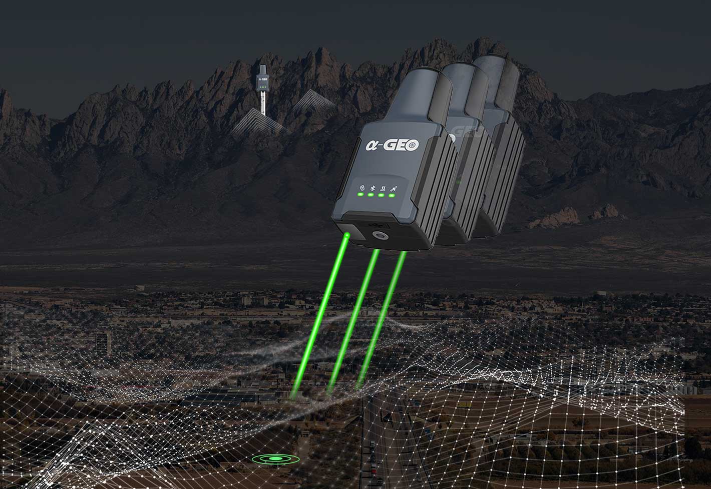
Laser Surveying
The world's exclusive patented laser coordinate measurement quick calibration technology can easily achieve centimeter-level measurement accuracy, making measurement more accurate and user-friendly. Besides the green laser module used in the equipment overcomes the difficulty of aiming under sunlight, making field measurement operations faster and more efficient.
-
 Military-level technology
Military-level processing technology, complete electromagnetic compatibility and shielding technology, minimize system electromagnetic interference, and ensure high-quality observation data and results.
Military-level technology
Military-level processing technology, complete electromagnetic compatibility and shielding technology, minimize system electromagnetic interference, and ensure high-quality observation data and results. -
 Multi constellation
GeoPuls with its 1408 channels new generation full GNSS chipset ability to support multiple satellite constellation including GPS, GLONASS, BEIDOU, GALILEO, OZSS, SBAS and IRNSS provides precise and accurate spatial data for all users around the world.
Multi constellation
GeoPuls with its 1408 channels new generation full GNSS chipset ability to support multiple satellite constellation including GPS, GLONASS, BEIDOU, GALILEO, OZSS, SBAS and IRNSS provides precise and accurate spatial data for all users around the world. -
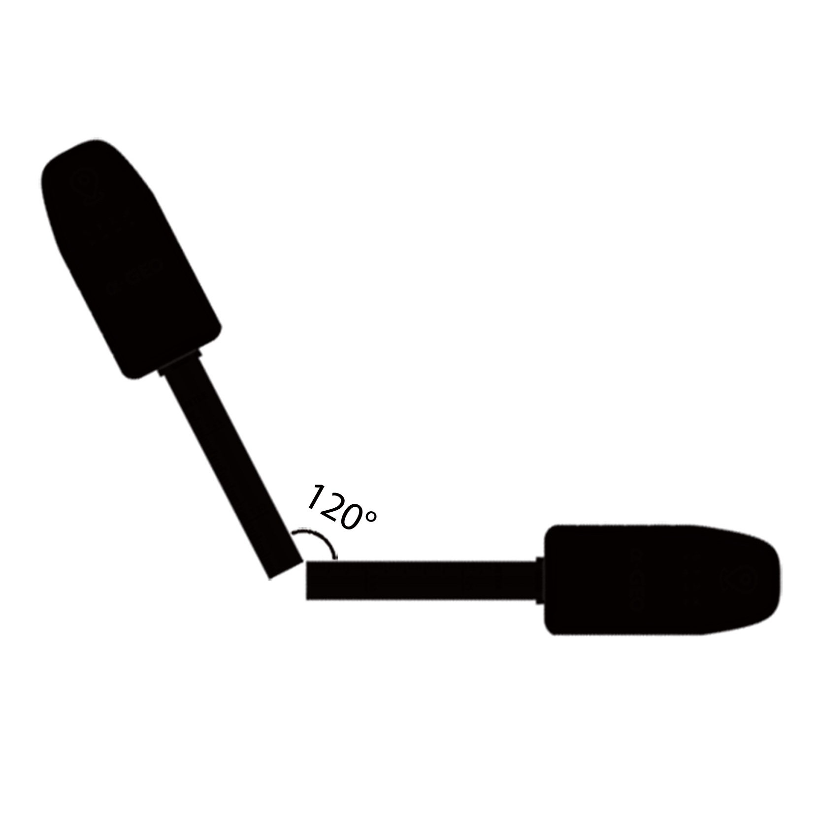 IMU Tilt Sensor
GeoPuls is equipped with a fast initialization, calibration free and immune to magnetic interference inertial Measurement Unit (IMU). All users can use this technology to collect or stakeout topo points up to 120°
IMU Tilt Sensor
GeoPuls is equipped with a fast initialization, calibration free and immune to magnetic interference inertial Measurement Unit (IMU). All users can use this technology to collect or stakeout topo points up to 120°
-
 Dual-mode Bluetooth
It supports Basic Rate and Enhanced Data Rate operation of traditional Bluetooth, and also supports the latest low-power standard, dual-mode industrial-grade high-speed SPP3.0+ble5.0, suitable for Android/ISO/PC.
Dual-mode Bluetooth
It supports Basic Rate and Enhanced Data Rate operation of traditional Bluetooth, and also supports the latest low-power standard, dual-mode industrial-grade high-speed SPP3.0+ble5.0, suitable for Android/ISO/PC. -
 GSM
A fast internet connection is guaranteed with a built-in 4G module that accelerate receiving correction data using all telecommunication signals and bands.
GSM
A fast internet connection is guaranteed with a built-in 4G module that accelerate receiving correction data using all telecommunication signals and bands. -
 IP67
Strictly measured IP67 waterproof and dustproof grade, sturdy and durable, completely suitable for harsh outdoor environments.
IP67
Strictly measured IP67 waterproof and dustproof grade, sturdy and durable, completely suitable for harsh outdoor environments.
Specifications
| Performance specification | Satellite signals tracked simultaneously | GPS: L1 C/A, L2C, L2P, L5 |
| GLONASS: L1,L2 | ||
| BEIDOU: B1,B2,B3,B1C,B2a, B2b | ||
| GALILEO: E1/E5a/E5b/E6 | ||
| QZSS: L1/L2/L5/L6 | ||
| SBAS:WAAS,EGNOS, MSAS,GAGAN,SDCM | ||
| Channels | 1408 | |
| Cold start | <60 s | |
| Hot start | <15 s | |
| Positioning output rate | 1Hz-50Hz | |
| Signal Reacquisition | <1s | |
| RTK Initialization time | <5s | |
| Initialization Reliability | >99.99% | |
| Time accuracy | 20 ns | |
| Positioning 1 | Static GNSS surveying | Horizontal:±(2.5mm + 0.5ppm) |
| Vertical:±(5mm + 0.5ppm) | ||
| RTK surveying | Horizontal:±(8mm+ 1.0ppm) | |
| Vertical:±(15mm+ 1.0ppm) | ||
| Laser surveying | ±1cm+5mm/m | |
| Communication & Data Storage | I/O interface | USB TypeC |
| Cellular | Integrated full frequency multi band 4G modem, supports WCDMA/CDMA2000/TDD-LTE/FDD-LTE | |
| Bluetooth | Dual-mode Bluetooth | |
| Data format |
Differential data:
RTCM2.X、RTCM3.X
|
|
|
GPS output data format:
NMEA 0183s RTK, Binary code
|
||
| ELECTRYCAL | Power: 5V/2A | |
| Support USB Type-C fast charging | ||
| Internal 3350 mAh battery | ||
| Battery Life >12 h | ||
| PHYSYCAL | Material | Polymer Engineering Materials |
| Dimensions | 136.5x65x56(mm) | |
| Weight | 300g | |
| Key | Power button | |
| Indicator | Power indicator, data link indicator, satellite indicator, Bluetooth indicator | |
| Operating temperature | -20°C to + 75°C | |
| Storage temperature | -40°C to + 85°C | |
| Protection lP | IP67 dust proof, protected from 30min immersion to depth of 1m | |
| Shock | Survive 2 m drop onto the concrete | |
| Vibration | MIL-STD-810G | |
| Humidity | 100%,condensing | |
| IMU | IMU | Supported, 4D lMU initialization in 3 seconds |
| IMU update rate | 400HZ | |
| IMU accuracy | <2.5cm within120° | |
| IMU tilt compensation | 0-120° | |
Hot Tags
Related Products

Matrix III Pro
Long-Range Laser+AR

Falcon X
RTK & Slam Hybrid Measuring System

1408 channels GNSS receiver NetBOX2 for any surveying project

1408 channels compact new generation of smart GNSS receiver L300 for any surveying project
Get a free quote in 24h
Rest assured that your privacy is important to us, and all information provided will be handled with the utmost confidentiality.
α-GEO, founded in 2008, is a global market-leading high-tech company focusing on high-precision GNSS technology.
alphageognss
alphageo
alphageoinfo