


Smallest handheld laser RTK L2 Plus for most measurement scenarios.


Unforgettable at first sight
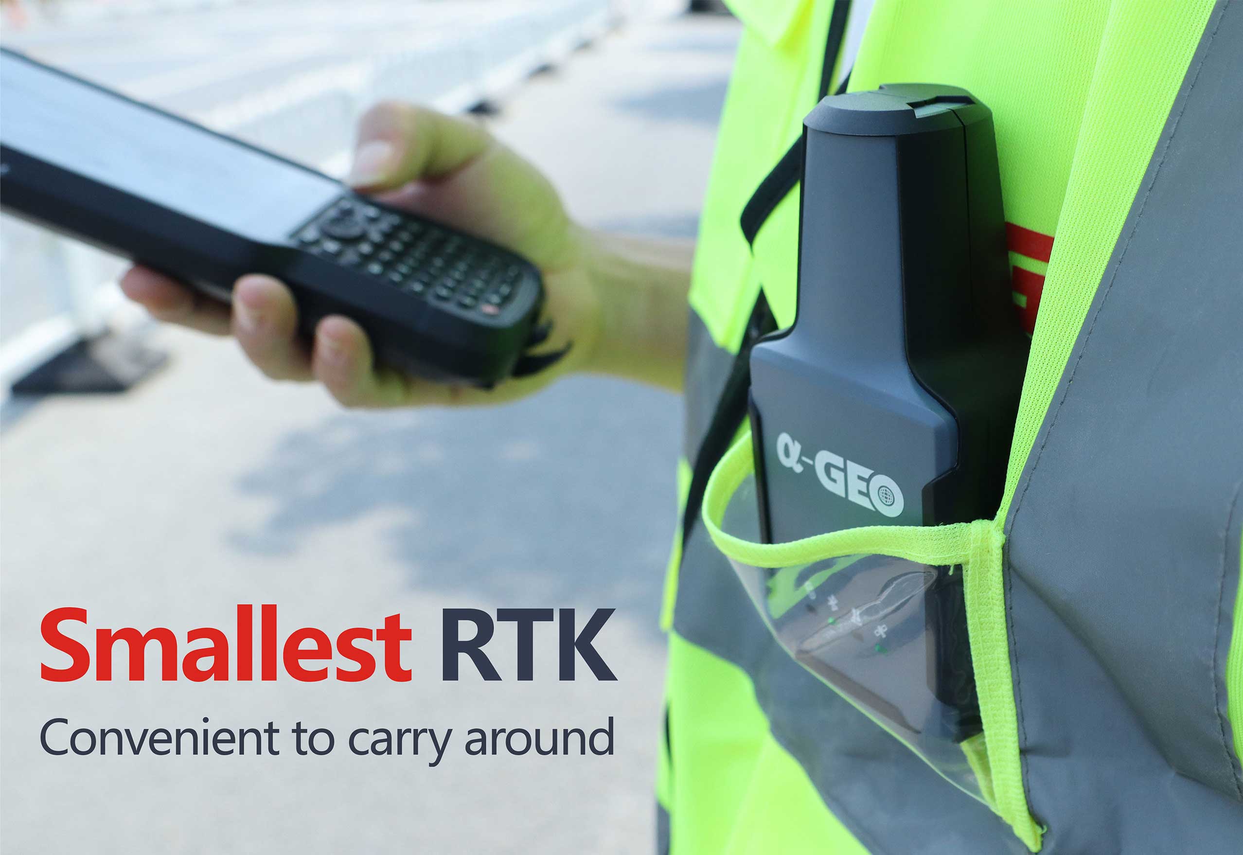
L2 Plus impresses with its unique design and ultra-small body size, the dimension of this RTK receiver is only 61(L)x41(W)x120(H)mm, such asmall size RTK receiver can take the place of cellphone that putting it into the pocketis not a problem. And the weight of L2 Plus is only 170g including internal battery,extremely lightweight that you almost don't feel tired while you hold it for along time in the field work. The housing of L2 Plus is made of polymer engineering materials,which has advantages of high strength, high temperature resistance and corrosion resistance, performing well in complex environments.

Walking ahead in the surveying
L2 Plus fusion laser measurement technology, which can quick calibrate and easily achieve centimeter-level measurement accuracy, capturing a high-precision coordinate for the target point.
With laser measurement, surveyors can collect the coordinate of points that they cannot reach directly or in dangerous places, like the high voltage towers, manhole covers on busy roads, ensuring the safety of personnel. L2 Plus shoots a green laser beam that brings unexpected results brighter laser beam can be found on the target easily, shoot further distance and achieve higher accuracy, which is more suitable for outdoor scenarios.

Signal capturing expert
Empowered by powerful signals tracking algorithm.and with the 1408 channels of GNSS engine, L2 Plus is able to track enormous signals of all running satellite constellations quickly,even weak signals can be captured, which improves the fixed rate andspeed, so you don't need to wait a long time to get the fixed solution as used to be.
Such an excellent engine algorithm and calculating capability, that is more than enough to let you easily navigate in complex environments,such as in the thick forest or beside the high buildings,the accuracy can be ensured.

Super Inertial Measurement Unit
The application of lMU in the RTK is a revolutionary advancement.L2 Plus is equipped with a new generation of lMU module as standard,which is fast initialization,calibration free and immune to magnetic interference.
It's incredible how powerful this small body is, it can help you to collect or stakeout the accurate topo points coordinate faster and easier. Moreover.the inclination angle can be up to 120°so that you can reach to a higher target point.
Specifications
| GNSS Performance | Channels | 1408 |
| Data Format | RTCM2.X、RTCM3.X | |
| Signals tracking | GPS: L1C/A,L2C,L2P, L5 | |
| GLONASS: L1,L2 | ||
| BDS: B1,B1C, B2, B2a, B2b, B3 | ||
| GALILEO: E1, E5a, E5b, E6 | ||
| QZSS: L1, L2, L5, L6 | ||
| SBAS: WAAS, EGNOS, MSAS, GAGAN, SDCM | ||
| Cold start | <60s | |
| Hot start | <15s | |
| Positioning output rate | 1Hz~50HZ | |
| Signal reacquisition | <1s | |
| RTK initialization time | <5s | |
| Initialization reliability | >99.99% | |
| Time accuracy | 20ns | |
| Positioning accuracy* | Static GNSS surveying | H:±(2.5mm+0.5ppm) |
| V:±(5mm+0.5ppm) | ||
| RTK surveying | H:±(8mm+ 1ppm) | |
| V:±(15mm+1ppm) | ||
| Laser surveying | ±1cmm+5mm/m | |
| IMU | Sensor | Supported,4D lMU |
| initialization in 3 seconds | ||
| Update rate | 400Hz | |
| Accuracy | <2.5cm within 120° | |
| Tilt compensation | 0~120% | |
| Communications | l/O interface | Type-C |
| Bluetooth | Bluetooth V4.0 | |
| Electrical | Battery | Built-in Li-ion battery,supports external power supply |
| Capacity | 2000mAh | |
| Battery life | >12hrs | |
| Interface | Type-C 5V/2A | |
| Environmental | Operating temperature | -20°C~+75°C |
| Storage temperature | -40°C~+85°C | |
| Protection IP | IP67 | |
| Shockproof | Survive a 2m pole drop onto concrete | |
| Vibration | MIL-STD-810G | |
| Humidity | 100%Non-condensing | |
| Physical | Dimensions | 120mmx61mmx41mm |
| Weight | 170g | |
| Materials | Polymer engineering materials | |
| Keys | Power button | |
| Indicators | 1*Satellite indicator | |
| 1*Bluetooth indicator | ||
| 1*Data communication | ||
| 1*Power indicator |
Hot Tags
Related Products


Get a free quote in 24h
Rest assured that your privacy is important to us, and all information provided will be handled with the utmost confidentiality.
α-GEO, founded in 2008, is a global market-leading high-tech company focusing on high-precision GNSS technology.
alphageognss
alphageo
alphageoinfo